- ZABAGED - HOME PAGE
- Introduction
- 1. Settlement, economic and cultural features
- 2. Transport infrastructure
- 3. Distribution networks and pipelines
- 4. Waters
-
5. Territorial units, including protected areas
- 5.01 BOUNDARY OF ADMINISTRATIVE UNIT AND CADASTRE UNIT
- 5.13 DEFINITION POINT OF A PART OF MUNICIPALITY
- 5.14 ADMINISTRATIVE UNIT DEFINITION POINT
- attributes:
- KODUTJ
- NAZEVUTJ
- KODNUTS1
- NAZEVNUTS1
- KODNUTS2
- NAZEVNUTS2
- KODNUTS3
- NAZEVNUTS3
- KODLAU1
- NAZEVLAU1
- KODORP
- NAZEVORP
- KODOPU
- NAZEVOPU
- KODLAU2
- NAZEVLAU2
- KODKU
- NAZEVKU
- KODSO
- NAZEVSO
- KODMC
- NAZEVMC
- TYPOBCE
- POCOBYV
- POCOBYV_MC
- KODMO
- ZM10
- TYPDBKU_K
- TYPDBKU_P
- TYPDBOBC_K
- TYPDBOBC_P
- TYPDBOPU_K
- TYPDBOPU_P
- TYPDBORP_K
- TYPDBORP_P
- VYZNAM_DB
- FID_ZBG
- 5.15 SMALL SPECIALLY PROTECTED AREA
- 5.16 LARGE SPECIALLY PROTECTED AREA
- 5.17 MINING AREA (*)
- 5.18 PROTECTED DEPOSIT AREA *)
- 5.19 SPECIAL PROTECTION AREA
- 5.20 SPECIAL AREA OF CONSERVATION
- 6. Vegetation and grounds
- 7. Terrain relief
- 8. Survey control points
- OVERVIEW OF CHANGES
| Feature category: | 5. Territorial units, including protected areas |
| Feature type: (with ordinal number) |
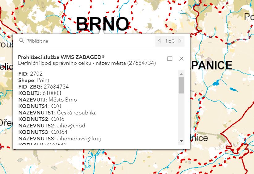
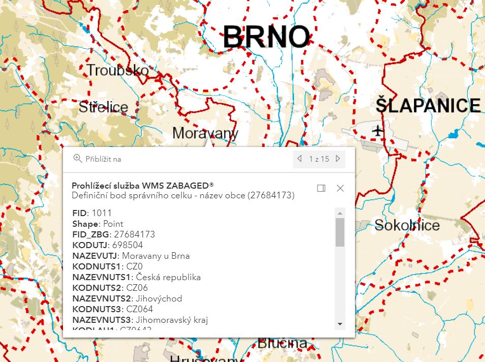
5.14 ADMINISTRATIVE UNIT DEFINITION POINT (DEFINIČNÍ BOD SPRÁVNÍHO CELKU) |
| Feature type code: | sb001 |
|
Feature definition: The point to which information on the categorization of a given territory into the current territorial division of the state is related. |
| Geometric determination of the feature: | point |
| Positional accuracy: | - |
| Geometric data source: | ČSÚ |
| Descriptive data source: | ČSÚ |
| A t t r i b u t e s : |
| Attribute name | Data type | Attribute subject | Attribute values | Code list |
| KODUTJ | NUMBER(6,0) | ÚTJ code | ||
| NAZEVUTJ | VARCHAR2(50) | ÚTJ name | ||
| KODNUTS1 | CHAR(3) | state code according to CZ-NUTS1 | ||
| NAZEVNUTS1 | CHAR(15) | state name | ||
| KODNUTS2 | VARCHAR2(4) | area code according to CZ-NUTS2 | ||
| NAZEVNUTS2 | VARCHAR2(50) | area name | ||
| KODNUTS3 | VARCHAR2(5) | region code according to CZ-NUTS3 | ||
| NAZEVNUTS3 | VARCHAR2(50) | region name | ||
| KODLAU1 | VARCHAR2(6) | district code according to LAU | ||
| NAZEVLAU1 | VARCHAR2(50) | district name | ||
| KODORP | NUMBER(4,0) | code of municipality with extended competence according to the ČSÚ | ||
| NAZEVORP | VARCHAR2(50) | name of municipality with extended competence (ORP) | ||
| KODOPU | NUMBER(5,0) | code of the municipality with an authorized office (OPÚ) according to the ČSÚ | ||
| NAZEVOPU | VARCHAR2(50) | name of the municipality with an authorized office (OPÚ) | ||
| KODLAU2 | NUMBER(6,0) | municipality code according to the local territorial statistical unit LAU | ||
| NAZEVLAU2 | VARCHAR2(50) | municipality name | ||
| KODKU | NUMBER(6,0) | code of cadastre unit according to the ČSÚ | ||
| NAZEVKU | VARCHAR2(50) | name of cadastre unit (KÚ) | ||
| KODSO | NUMBER(4,0) | code of the administration area according to the ČSÚ | ||
| NAZEVSO | VARCHAR2(50) | name of the administration area | ||
| KODMC | NUMBER(6,0) | code of the town district according to ČSÚ | ||
| NAZEVMC | VARCHAR2(50) | name of the town district | ||
| TYPOBCE | VARCHAR2(20) | municipality type | capital, statutory town, town, small town, municipality, military district | |
| POCOBYV | NUMBER(10,0) | current number of inhabitants of the municipality | ||
| POCOBYV_MC | NUMBER(8,0) | number of inhabitants of MČ / MO (as of the last census) | ||
| KODMO | VARCHAR2(2) | code of the town of Prague district | ||
| ZM10 | VARCHAR2(8) | nomenclature of 1: 10 000 Basic map with the municipality definition point | ||
| TYPDBKU_K
TYPDBKU_P |
NUMBER(3,0)
VARCHAR2(100) |
character of the definition point for the KÚ | C_TYPDBODU | |
| TYPDBOBC_K
TYPDBOBC_P |
NUMBER(3,0)
VARCHAR2(100) |
character of the definition point for the MUNICIPALITY | C_TYPDBODU | |
| TYPDBOPU_K
TYPDBOPU_P |
NUMBER(3,0)
VARCHAR2(100) |
character of the definition point for the OPÚ | C_TYPDBODU | |
| TYPDBORP_K
TYPDBORP_P |
NUMBER(3,0)
VARCHAR2(100) |
character of the definition point for the ORP | C_TYPDBODU | |
| VYZNAM_DB | VARCHAR2(100) | meaning of the definition point | list of unit types where given point is a definition point | |
| FID_ZBG | VARCHAR2(40) | unique feature identifier in ZABAGED® |
| S i z e r e s t r i c t i o n s : |
| without restriction |
| E x a m p l e s : |
|
| F e a t u r e h i s t o r y : |
Extended web version updated to: 01.07.2026
Contact: Content Guarantor: Petr Neckář (e-mail: Petr.Neckar@cuzk.gov.cz; tel: +420 284 041 667)
Content Filling: Marek.Popp@cuzk.gov.cz | Technical Solution: Antonin.Baco@cuzk.gov.cz, Petr.Cerveny@cuzk.gov.cz
Contact: Content Guarantor: Petr Neckář (e-mail: Petr.Neckar@cuzk.gov.cz; tel: +420 284 041 667)
Content Filling: Marek.Popp@cuzk.gov.cz | Technical Solution: Antonin.Baco@cuzk.gov.cz, Petr.Cerveny@cuzk.gov.cz